
The late Bill Chase must have been driving taxi around town when he realized Kentville had changed drastically since he was a boy; for one thing, many of the stores and houses he remembered had disappeared.
Chase was born in Kentville in 1926 and went to school at Kings County Academy. He operated Star Taxi in Kentville in the 1950s and likely noticed firsthand how the town had changed since his school days. He decided to record those changes and a detailed street map, which he left to a niece, was the result.
Why Chase decided to make a map of Kentville’s retail section as it existed in 1938 is immaterial. But historians such as Kentville’s Louis Comeau are grateful that he did. “The town has changed since the map was created,” Comeau said, “and many memorable buildings aren’t there anymore. Chase puts names on those buildings, pinpoints where they were located, making it a valuable record and a great research tool.”
Comeau’s sentiments are echoed by a director of the Kentville Historical Society: “This is a wonderful find,” Lynn Pulsifer said when told about the map. “Hopefully, the map might one day be displayed in the Society’s newly opened museum,” she said in effect.
Chase’s map was left to his niece, Joan Jefferson, who said she isn’t sure when he put it together. “He did it from memory after coming home from Ontario and opening a business in Kentville.”
Ms. Jefferson and Chase’s nephew, Bob Masters, plan to donate the map to the Kentville Historical Society and tentatively it will be offered to that body this June.
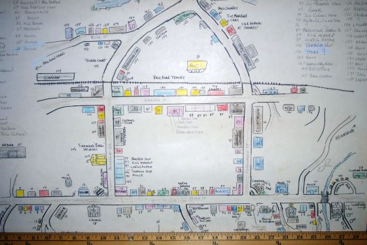
Chase was meticulous about details when he created the map. Approximately 172 sites with retail stores, restaurants, gas stations, automotive dealers, churches residences and other types of businesses (two blacksmiths, for example) are recorded. Chase concentrated on Kentville’s major streets, Main, Cornwallis Webster and Aberdeen, where most of the town’s retail and other businesses were located.
This area is drastically different today, and Main Street is the most changed. According to the map, in 1938 this street contained two movie theaters, a bus terminal, two restaurants, two service stations, a car dealership, a jewelry store, a newspaper office, a department store, a mail order office, a dry cleaner, a photography studio and a monument dealer. Only a few of these retailer stores and businesses can be found on Main Street today.
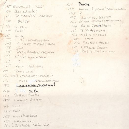
Chase’s map indicates that the decline that hit Main Street, also hit other retail stores in and just outside town limits. The map makes it easy to determine which retailers disappeared and where they were located. This was made possible since Chase numbered every retail store, every building and every residence he placed in his map and included an index to them.
After examining the map, Louis Comeau said that based on the research he has done, it accurately records what the town once was like. “The index, indicating where most of the older buildings once stood, makes the map a valuable tool for researchers,” he said.
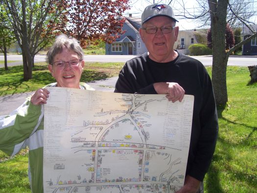
Joan Jefferson and Bob Masters with the map their uncle Bill Chase made of the Kentville retail area as it was circa 1938. They plan to donate the map to the Kentville Historical Society. (Ed Coleman)
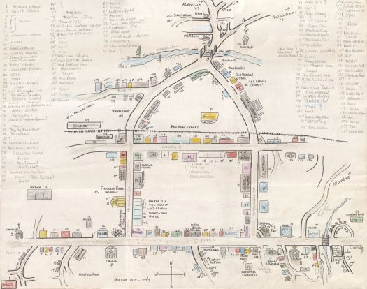
Bill Chase’s map of downtown Kentville as it was around 1938 when he was a schoolboy. (Submitted)
Map scale
Back of map (legend continued)
